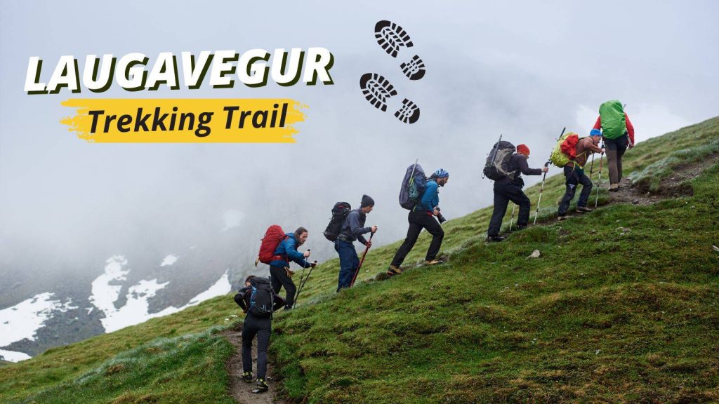
The Laugavegur trekking trail is one of Iceland’s most iconic hiking routes, offering a powerful journey through colorful mountains, geothermal fields, black deserts, glacial valleys, and ever-changing landscapes. Every step reveals a new side of Iceland’s wild beauty, making this trek a favorite for adventurers worldwide.
Top 10 Hidden Fjords in East Iceland That Most Tourists Miss
Planning to hike independently, join a guided group, or extend your route to Skogafoss, Find best season, essential gear, a full day-by-day itinerary, and key safety tips designed to help you visit the Laugavegur trekking trail with confidence and clarity.
About Laugavegur Trail Trekking
The Laugavegur trekking trail is widely regarded as Iceland’s most stunning multi-day hike. It stretches across 55 kilometers of diverse terrain, connecting Landmannalaugar, known for its brightly colored rhyolite mountains and natural hot springs, with Thorsmork, a beautiful, sheltered valley surrounded by volcanoes and glaciers.
What makes this trail incredibly special is its constantly changing landscape. One moment you are walking through bubbling geothermal fields with sulfur fumes rising from the earth, and the next moment the terrain transforms into black sand plains that look like something straight out of a sci-fi movie. With its dramatic contrast of colors and textures, the trail gives hikers the rare chance to witness millions of years of geological history and volcanic activity in just a few days.
This trek is popular among both beginner and experienced hikers, attracting thousands each summer. Many who complete it say the experience is emotional, peaceful, physically rewarding, and deeply inspiring. It offers a kind of silence and solitude that is increasingly rare in the modern world.
Where Is the Laugavegur Trek Located?
The Laugavegur trekking trail runs through Iceland’s remote Highlands, one of Europe’s largest uninhabited wilderness areas. This rugged region challenges hikers with rough terrain, sudden weather changes, and untouched natural landscapes. Hikers can access the trail only during the short summer season, making it an exclusive adventure for those prepared to explore Iceland’s raw wilderness.
Trail starts in Landmannalaugar, a geothermal hotspot known for its colorful rhyolite mountains. These mountains display vivid shades of red, orange, yellow, green, and blue, creating a landscape that feels almost surreal. Hikers often explore lava fields, trek nearby short trails, and soak in natural hot springs to relax before or after their daily hike.
The trail ends in Thórsmörk, a fertile valley surrounded by glaciers like Eyjafjallajökull and Mýrdalsjökull. Birch forests, wildflowers, and panoramic views dominate the scenery, offering a dramatic contrast to the volcanic deserts trekked earlier. After several days of hiking, arriving in Thórsmörk feels like stepping into a hidden paradise, rewarding hikers with some of Iceland’s most breathtaking landscapes.
Best Time to Hike the Laugavegur Trail
Because the Laugavegur trekking trail sits deep within the Highlands, its accessibility depends greatly on Iceland’s weather. The trail officially opens only during the summer months when melting snow allows safe passage.
Ideal Hiking Season: Late June to Early September
During this period, the snow has mostly melted, river levels become manageable for crossings, and mountain huts along the trail open for accommodation. Daylight hours are extremely long during the peak summer months, giving hikers more time to enjoy each day at a comfortable pace. However, the weather can still change suddenly—sunshine can quickly shift to cold winds, fog, or rain—so proper gear is crucial.
Attempting the trek outside this short season is unsafe because the trail becomes buried under snow, river crossings grow dangerous, and access roads are closed.
How Long Is the Laugavegur Trek?
The Laugavegur trekking trail stretches approximately 55 kilometers (34 miles), offering a multi-day adventure through some of Iceland’s most dramatic landscapes. Most hikers complete the trek in four days, but the duration can vary depending on factors such as fitness level, weather conditions, and whether you choose to extend your journey via the optional Fimmvorouhals trail for even more volcanic scenery and glacier views.
Difficulty Level: Moderate to Challenging
Although the trail does not require technical climbing skills, it presents several challenges that demand endurance, preparation, and focus. Hikers must tackle:
- Long walking hours each day, often over uneven and rugged terrain.
- Steep sections that climb sharply uphill and descend quickly downhill.
- Multiple river crossings, many of which have no bridges, requiring careful navigation.
- Exposure to unpredictable weather, including sudden rain, wind, or even snow patches at higher elevations.
- Varied surfaces, such as volcanic rocks, black sand, snowfields, and loose gravel, which test balance and stamina.
With proper preparation, the trail is achievable for hikers with average fitness levels. Those who pace themselves, carry essential gear, and stay aware of changing conditions can successfully complete this unforgettable trek across Iceland’s raw and diverse landscapes.
Laugavegbur Trekking Itinerary (Day-by-Day Guide)
Following is a complete day-by-day breakdown of the Laugavegur trekking trail, highlighting landscapes, natural wonders, and what hikers experience at every stage.
Day 1: Landmannalaugar → Hrafntinnusker (12 km)
You start your trek in Landmannalaugar, a geothermal wonderland where the trail immediately immerses you in Iceland’s vibrant colors and unique landscapes. The mountains glow in reds, yellows, greens, and blues, while the scent of sulfur drifts from steaming vents and natural hot springs.
As you ascend from the valley, the terrain grows more dramatic. Cooling lava fields stretch along the path, and snow patches cling to the slopes even in summer. Your climb gradually leads to Hrafntinnusker, one of the trail’s highest points. Here, vast obsidian fields glitter like black glass under the sunlight, creating a mysterious, otherworldly atmosphere.
The cold wind and occasional snow remind you that you are in Iceland’s high-altitude wilderness. Reaching the Hrafntinnusker hut feels like stepping into a remote outpost, offering a welcome rest at the end of your first challenging day.
Day 2: Hrafntinnusker → Álftavatn (12 km)
On day two, the scenery transforms dramatically. You descend from the snowy plateau into a broad, green valley, passing rolling hills and deep ravines carved by glacial melt over millennia. The landscape feels gentler, and the day’s hike allows you to relax and enjoy the beauty around you.
Day culminates at Lake Álftavatn, a serene body of water surrounded by open spaces and distant mountains. The calm surface reflects the sky perfectly, especially during sunset, creating a picture-perfect setting. Compared to Day 1, this stage feels easier, giving your legs a chance to recover while still offering awe-inspiring vistas.
Day 3: Alftavatn → Emstrur (16 km)
Day three introduces hikers to one of the most dramatic and surreal landscapes of the trail. You enter vast black sand deserts formed by volcanic eruptions, stretching endlessly and evoking a lunar-like atmosphere.
River crossings appear along the way, with icy waters that require careful footing. Many hikers use specialized river shoes to navigate safely. As you approach Emstrur, the landscape shifts once again—deep canyons, rugged rock formations, and distant glaciers dominate the view. The Emstrur huts sit in a sheltered area, providing a comfortable resting spot before the final push to Thórsmörk.
Day 4: Emstrur → Thorsmork (15 km)
The final day reveals one of the most rewarding transformations of the trek. After days of barren volcanic terrain, the environment becomes lush and green, with moss-covered hills, small forests, wildflowers, and streams guiding your path.
You enter Thorsmork, a fertile valley protected by surrounding glaciers and mountains. The area enjoys a warmer microclimate, allowing birch forests and diverse vegetation to thrive. Trails wind through this magical landscape, offering breathtaking views of glaciers and volcanic peaks.
Reaching Thorsmork marks the triumphant end of the trek. After days of hiking through Iceland’s raw wilderness, you are rewarded with one of the country’s most spectacular and memorable landscapes—a fitting conclusion to the Laugavegur trekking trail.
Accommodation on the Laugavegur Trail
Hikers on the Laugavegur trekking trail can choose between mountain huts and camping, depending on budget, comfort preferences, and desired experience. Both options allow you to immerse yourself in Iceland’s remote wilderness while providing essential amenities for a safe and enjoyable trek.
Mountain Huts
The trail features several mountain huts strategically placed along the route, providing basic but comfortable lodging. These huts typically include:
- Bunk beds with mattresses and blankets
- Shared kitchens where hikers can cook meals
- Communal bathrooms and washing facilities
Mountain huts offer warmth, shelter, and a reliable place to rest after long days of hiking. Staying in a hut also gives you the chance to meet fellow trekkers from around the world, share experiences, and exchange tips for the next day’s hike.
Because these huts are very popular, especially during peak season in July and August, reservations must be made months in advance. Hikers should plan ahead to secure spots and avoid disappointment, as space is limited and huts often reach full capacity.
Camping
Who prefer a more budget-friendly or adventurous option, camping is available near each hut. Campers can pitch tents in designated areas close to the huts, gaining access to shared facilities such as toilets and water sources.
Camping offers the freedom to enjoy Iceland’s wilderness more intimately, falling asleep under a starry sky or even the midnight sun. However, hikers must be prepared for unpredictable weather. Strong winds, rain, or sudden temperature drops can make camping challenging, so carrying a high-quality, weatherproof tent and warm sleeping gear is essential.
Camping combines affordability with adventure, letting hikers experience the trail in a more personal, flexible way while still benefiting from the infrastructure provided near each hut.
Completing this hike will leave you with unforgettable memories, a deeper appreciation for nature, and a connection to Iceland’s wild heart.
FAQs
1. How do I prepare physically for the Laugavegur trek?
To hike the Laugavegur trekking trail comfortably, it’s important to build stamina and strength before your trip. Focus on long walks or hikes with a weighted backpack to simulate trail conditions. Include hill climbs, core exercises, and leg-strength routines. Practicing river crossings with water shoes or trekking poles can also help prepare for real trail conditions.
2. How challenging are river crossings?
River crossings on the trail are a unique aspect of hiking in Iceland. Most rivers are shallow in summer, ranging from knee to waist height, but currents can be strong and unpredictable after rain. Trekking poles, proper footwear, and crossing in groups improve safety. Hikers should always assess water levels and avoid crossing during heavy rains.
3. Is there mobile network or Wi-Fi on the trail?
The Laugavegur trail passes through remote areas where mobile coverage is extremely limited. Most mountain huts do not provide Wi-Fi, so don’t rely on online navigation. Hikers are advised to download offline maps, GPS apps, and safety tools like the Safetravel Iceland app. Inform someone of your itinerary before starting the trek.
4. Can the trail be done in less than 4 days?
Yes, experienced hikers sometimes complete the trail in 2–3 days, but this requires long daily hikes of 20 km or more. Shortening the schedule reduces time for rest, photography, and enjoying landscapes. It is recommended only for hikers with good fitness, experience with multi-day treks, and familiarity with changing Icelandic weather.
5. Can children hike the Laugavegur trail?
Hiking with children is possible for those aged 10 and above, provided they have sufficient stamina and are accustomed to long walks. Families are advised to stick to shorter daily segments, take extra breaks, and stay in mountain huts rather than camping. Always check weather conditions and river depths before attempting sections with children.
6. What wildlife might I see on the trail?
Iceland’s Highlands are home to unique wildlife, although sightings are relatively rare. Hikers may encounter Arctic foxes, migratory birds such as puffins and golden plovers, and insects near rivers. There are no dangerous large mammals, making the trail safe for hikers. Observing wildlife requires patience and keeping a respectful distance.
7. Are there side trails along Laugavegur?
Yes, adventurous hikers can explore several side routes. The most popular is the Fimmvörðuháls Trail, extending to Skógafoss waterfall, which adds glaciers and fresh lava fields to the experience. Other short detours include nearby geothermal springs, volcanic ridges, and highland viewpoints. Side trails require extra planning, fitness, and proper gear.
8. How unpredictable is the weather?
Weather on the trail can change dramatically in a single day. Hikers may experience sun, rain, snow, or strong winds within hours. Summer temperatures typically range from 5°C to 15°C, but wind chill can make it feel colder. Wearing layered clothing, checking daily forecasts, and having contingency plans are essential for safety and comfort.
9. How should I carry food and water?
Hikers need to carry sufficient food and water for the trek. Lightweight, high-energy meals like nuts, dried fruits, and freeze-dried foods are ideal. Rivers along the trail provide fresh water, but it must be filtered or purified before drinking. Most hikers carry 2–3 liters of water per day and refill along the route, planning for longer stretches without water sources.
10. Do I need permits for hiking the trail?
No official permit is required for hiking the Laugavegur trekking trail. However, accommodation in mountain huts must be booked in advance due to limited availability. Camping is only allowed in designated areas, and hikers must avoid walking on fragile moss or geothermal zones. Following these rules protects Iceland’s delicate ecosystems while ensuring a safe and responsible hike.